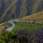
The hydrography of Argentina has an exceptional richness. Argentina has a large number of rivers throughout its territory and also has lakes, wetlands, lagoons, ice fields, and groundwater. Of the large number of watercourses that run through the country, most of which are navigable, some of them are of great hydroelectric importance.
CONTENT
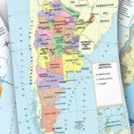
Rivers in Argentina Map with main Rivers and Tributaries
The most important hydrographic systems in Argentina belong to the Atlantic Slope. They are the Plata Basin and the Patagonian System. Argentina also has other water systems such as endorheic basins, the slope of the Pacific, and lakes and lagoons.
You can see the complete hydrographic system on the map below:

Major Rivers in Argentina
- The Río de la Plata is the widest in the world with 221 km (138 mi) shared by Argentina and Uruguay
- Paraná is 4,880 km (3,032 mi) long shared by Argentina, Brazil, and Paraguay. It is the second longest river in South America after the Amazon River.
- Paraguay is 2,695 km (1,629 mi) long shared by Argentina, Bolivia, Brazil, and Paraguay
- Uruguay is 1,838 km (1,142 mi) long shared by Argentina, Brazil, and Uruguay
- Río Salado 2355 km is part of the longest watercourse in Argentine territory. It is born in the Andes Mountains, adopts different names, and empties into the Atlantic Ocean through the Paraná River.
All five belong to the Plata Basin on the Atlantic Slope
It is worth clarifying that there are different types of basins, and they are classified according to the evacuation of water.
Source: Argentina.gob.ar Cuencas Hídricas Document
- Exorheic basins: are those whose waters reach the sea or ocean.
- Endorheic basins: are those whose waters do not reach the sea because the rivers flow into interior lagoons or because they are depleted by evaporation, infiltration, or consumption.
- Arreic basins: are those areas where fluvial courses are not defined, due to the lack of water in highly permeable soils.
Atlantic Slope
To recap, the hydrography of Argentina has the Atlantic Slope, in which two exorheic basins drain:
- Plata Basin
- Basin or Patagonian System
Plata Basin
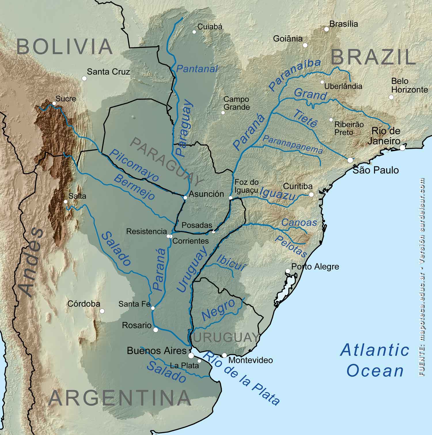
It comprises a total extension of 1,196,916 sq. mi. (3,100,000 km2). It is considered the most relevant in Argentina, it is the fifth most important basin in the world and the second in South America: rivers whose source is outside of Argentina belong to it; and cover territories of five countries Argentina, Bolivia, Brazil, Paraguay, and Uruguay.
The Plata basin collects water from the rivers that descend from the Puna, the Subandino System, Sierras Pameanas, Plain Pampas and Chaco, and Mesopotamia. For further information on these areas, we suggest seeing, Argentina: Geographical Regions
The main rivers belonging to it are Río de la Plata, Paraná, Uruguay, Paraguay, Salado, Carcarañá, and Iguazú.
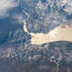
The Río de la Plata, belonging to the hydrography of Argentina, extends from the confluence of the Paraná and Uruguay to an imaginary line connecting Cape San Antonio, Argentina; with Punta del Este, Uruguay. Its length is 275 km and its estuary has 35,000 km2. The Río de la Plata (Plata River) is 25 mi. (40 km) wide as measured at Colonia (Uruguay) and 124 mi. (221 km), as measured between the extremes of its mouth. Besides, it is the river that gives its name to the basin and to the geographical region for which it sets the east boundary.
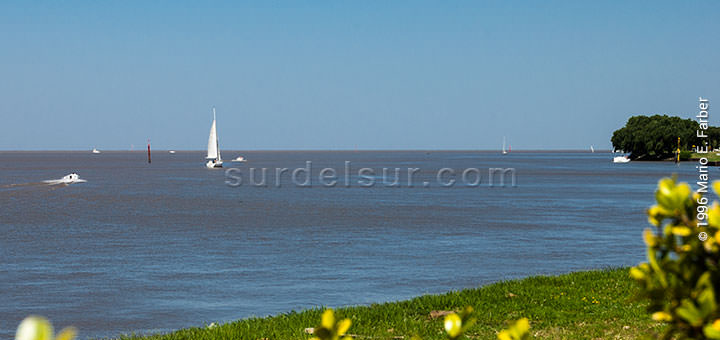
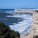
The Río de la Plata is an estuary that empties into the Argentine Sea. It is precisely called an estuary to the confluence between a river of great width and flow and the sea. Here we show you the place where the Río de la Plata meets the Atlantic Ocean:
Learn more about the Rio de la Plata the Widest in the World >>
Some other examples of the Plata Basin hydrographic systems are:
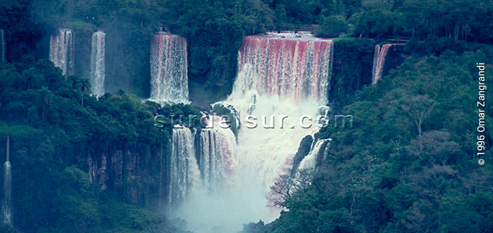
The Iguazú River is born in Brazil. The Cataratas del Iguazú (Iguazú Falls) is located on the Iguazú River, on the border between the Argentine province of Misiones and the Brazilian state of Paraná. They make up a protected area, they are a Natural Heritage of Humanity in Argentina designated by UNESCO in 1984, and are considered one of the Seven Natural Wonders of the World.
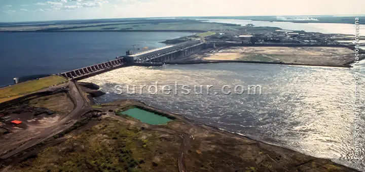
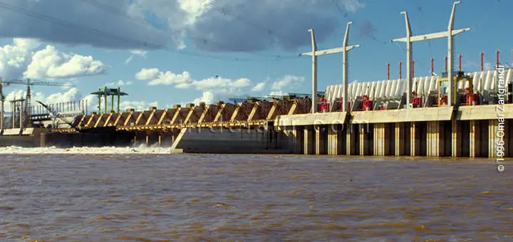
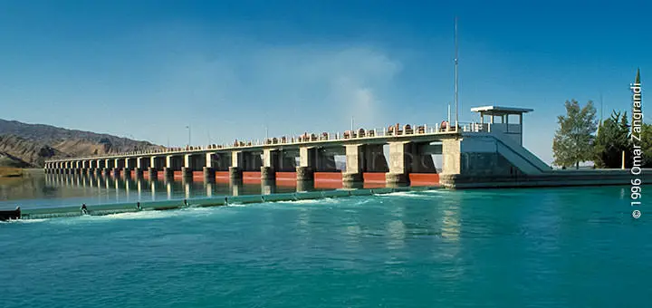
The Yacyretá Binational Hydroelectric Dam is a hydroelectric plant on the rapids of Apipé on the Parana River, near the island of Apipé Grande and Yacyretá Ituzaingó, in the Province of Corrientes, Argentina, and the Department of Itapua, Paraguay. The Paraná River rises in Brazil and in Argentine territory covers 1710 Km.
The Salto Grande Bridge is a rail and road bridge across the Uruguay River and is part of the Salto Grande hydroelectric complex.
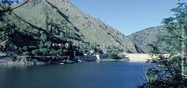
Binational Hydroelectric Central Salto Grande Dam and hydroelectric plant located on the site of Ayu, in the middle reaches of the Uruguay River, about 15 km north of the cities of Salto, Uruguay; and 18 Km from Concordia, Entre Ríos, Argentina.
The Uruguay River from Brazil runs 1170 km in Argentina and empties into the Rio de la Plata.

Embalse de Cabra Corral called General Manuel Belgrano Dam, rises in the river meeting Guachipas and Arias. The Guachipas River is the continuation of the Calchaqui River born on the eastern slope of the Andes, then takes the name of Pasaje o Juramento, Salado River, Paraná River, and finally empties into the Río de la Plata. Its 2355 km length is probably one of the waterways, longest in Argentina, and belongs to the Atlantic slope.
The Embalse de Río Tercero in Calamuchita, called Embalse Ministro Pistarini is on the Río Tercero and originates in the Pampa de Achala, Córdoba. Runs west-east direction, flows into the Paraná with the name River Carcarañá, and together with the Río Cuarto, are the only rivers of Córdoba tributaries of the Río de la Plata Basin.
Read more about the Hydroelectric importance of Argentina’s rivers >>
Patagonian System or Basin
The rivers belonging to the Atlantic Slope, which traverse Patagonia, compound this system. All of them are born in the cordillera and their flow is increased twice a year, in winter due to the rainfalls and in spring due to the snow thawing. The lowest level occurs in the fall.
For more details about the climate in Argentina click on Types of Climate in Argentina
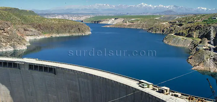
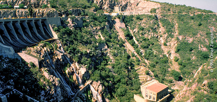
The Chocón Cerros Colorados is an example of the Patagonian System. This hydroelectric complex is located in the region called Comahue, which is part of the Argentine provinces of Río Negro, Neuquén, south of the provinces of Buenos Aires, and La Pampa. The Hydroelectric Complex comprises the central El Chocón and Arroyito on the Limay River, about 80 km upstream of its confluence with the river Neuquén.
The most important rivers of this Patagonian System are Limay Chubut, Santa Cruz, and Río Negro:
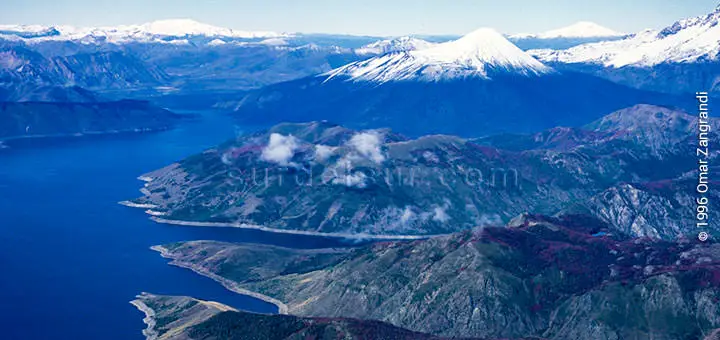
- The Limay River is an important watercourse in Argentine Patagonia, 617 km long. It has its origin in Lake Nahuel Huapi and flows in a northeasterly direction towards the Atlantic Ocean. It forms the natural limit between the provinces of Neuquén and Río Negro. Then it converges with the Neuquén River in the city of Neuquén, giving rise to the source of the Negro River.
- The Río Negro is the most important river in Patagonia and its flow is regulated by the Chocón. Then travels through a narrow valley plateau whose average width is 15 km., at the widest part of the river is the island of Choele Choel. The river empties into the Atlantic Ocean, after traveling 730 km, and not receives any tributary.
- The Chubut River is born in the Andes, in the Cerro de las Carreras, near Rio Negro province. Chubut River crosses the Province of Chubut from west to east along 810 km and flows into the Atlantic near the city of Rawson. At its confluence with the Chico River is the Florentino Ameghino Dam, which benefits the towns located along its course.
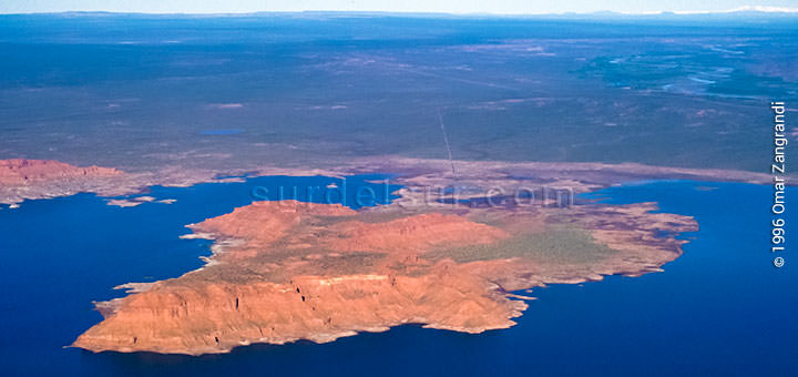
- The Santa Cruz River rises in Lake Argentino. Which brings its waters from Lake Viedma through the River La Leona. The water is glacial, from the melting of the glaciers of Glacier National Park home. The river has an average width of 150 m, and covers 385 km, or 543 km including its sources, from the east of Santa Cruz province up to the Atlantic Ocean, ending in a deep estuary, shared with the Chico River.
Endorheic Basin
Within hydrography in Argentina, the classification of Endorheic Basin are all the rivers not flowing into the sea, the waters end within the territory through filtration or evaporation.
Desaguadero Basin
This basin has great hydroelectric and irrigation significance and is considered temporary because, in times of great freshets, its waters can reach the sea.
It includes the following rivers: Jáchal, Mendoza, Tunuyán, Diamante, and Atuel. The Desaguadero River is the collector.
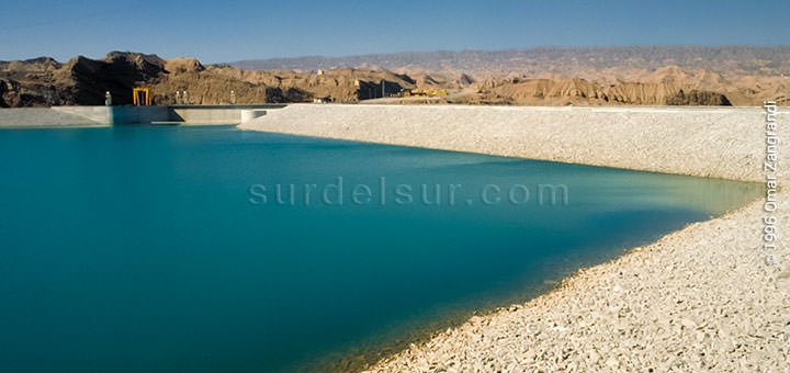
The Agua del Toro Dam is a hydroelectric dam for irrigation and flood control on the Diamante River, in the province of Mendoza, Argentina.

The Diamante River, born from glaciers on the Maipo volcano, in the Andes on the border with Chile, and flows east before emptying into the Desaguadero River. It is a fast river, snowy regime, carrying a low flow of water but at high speed.
The Atuel River is another Desaguadero River tributary that runs approximately 790 Km south of the Province of Mendoza.
The Tunuyán River it is located in the province of Mendoza. Born in the Tupungato volcano in the Andes, and passes through the city of Tunuyán. Until the dike El Carrizal is the “upper Tunuyán”, and starting from there the “lower Tunuyán” runs in total 220 km to the Desaguadero River.
The Ullum Dam is located on the San Juan River in the south-central province of San Juan, Argentina.
The San Juan River is a permanent watercourse, a glacial product of snowmelt in the Andes. Its course is 500 km long and the longest river in the region of Cuyo and the Desaguadero River Basin.
Basin of the Sierras Pampeanas
In the hydrography of Argentina, the Basin of the Sierras Pampeanas comprises streams of great relevance, hydroelectric and for irrigation.
It includes the following rivers: Salí, Primero, Segundo, Quinto, and other minor rivers.
Some examples of rivers and dams, in the Basin of the Sierras Pampeanas:
The Dique La Viña or Embalse Ing. Luis Antonio Medina Allende, is on the river the Sauces. This river is formed on the edge of Villa Cura Brochero and Mina Clavero from the confluence of the rivers Panaholma and Mina Clavero. Both are natural water channels in Traslasierra Valley, from streams of Pampa de Achala, and Córdoba hills.
The San Roque Dam collects water from the Río Primero caused by rainfall, regular magnitude, running through the valley of Punilla.
Los Molinos Dam is on the Rio Segundo, which lowers the highest sector, of the Sierras Grandes mountains.
Puna Basin
The rivers that cross the Puna, make up a closed basin, minor.
Pacific Slope
Also part of the river system in hydrography in Argentina, we find the Pacific Slope.
The Futaleufú Hydroelectric Complex, whose official name is Gral. San Martin, is on the Futaleufu River, Chubut province.
The Futaleufu River (also known as Grande) is a fluvial channel, fed by glacial lakes belonging to the Los Alerces National Park, in the province of Chubut, Argentina. The river crosses the Andes to Chile and flows into Lake Yelcho.
Lakes and Lagoons
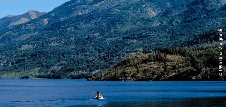
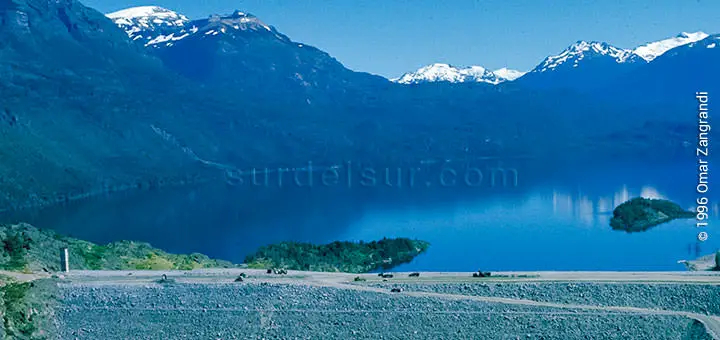
All the Argentine lakes are in the Patagonia, both in the Cordilleran and in the extra-cordilleran areas. Some of the cordilleran lakes are shared with Chile: General Vintter, Buenos Aires, Pueyrredón, San Martín y Fagnano; whereas the rest are exclusively under Argentine sovereignty.

The lakes of the Cordilleran area, exclusive sovereignty Argentina are Lago Argentino (1.415 km2), the biggest in Argentina; Viedma (1.088 km), Nahuel Huapi (550 km2), and other minor lakes.
The most important lakes from extra-cordilleran Patagonia are Colhué Huapi (803 km2) and Musters (434 km’), both in Chubut Province.
The lagoons are scattered along the whole Argentine territory:
There are some of marine origin, which tend to disappear and become salt-pits and others are water collections from rainfall or thawing.
Bibliography:
- Argentina.gob.ar Hydroelectric Power Plants List
- Argentina.gob.ar Energía Hidroeléctrica
WAS THE ARTICLE USEFUL TO YOU? SAVE IT!!
READ THE RELATED ARTICLE…!