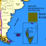
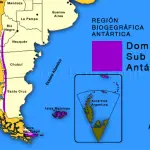
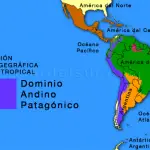
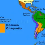
The Chaco Domain approximately coincides with the South American low lands. It has been divided into six provinces, five of which are represented in Argentina, where they encompass most of the country.
Article of the guest columnist, Esteban O. Lavilla y Juan A. González for surdelsur.com
See all reports about Biogeography of Argentina >>
Argentine Chaco Domain
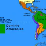
The Chaco Domain is part of the Neotropical Biogeographical Region of Argentina, along with the Amazonian Domain and the Andean-Patagonian Domain.
The 5 provinces that comprises the Chaco Domain are:
Pre-Puna Province
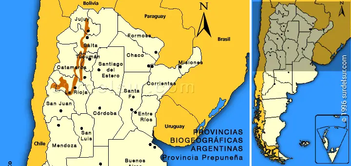
The Pre-Puna Province that belongs to the Chaco Domain encompasses the provinces of Jujuy, Salta, Tucumán, Catamarca and La Rioja.
It includes quebradas and dry mountain sides, between 2000 and 3400 m (6562 and 11154 feet) above sea level, although in some regions the heights can be remarkably lower. Its eastern limit varies in connection with the latitu de. In a north-south direction, it is bounded by the Yunga province, the Chaco province and the Woodland province in the east.
Climate
Warm and dry, with exclusively summer rainfalls which do not exceed the 200 mm (7.87 inches) per year.
Landscape
Mountain sides and quebradas, with rocky or sandy soils which are very much loose and immature.
Vegetation
It is generally shrubby, low and scattered, but cardón covered areas and bromeliad cushions can also be found.
Communities
Four climax communities have also been identified:
Shrubby steppe: It seems to be the most outstanding community, with prevailing gramineous and cactaceous legumes and it is found on soft slopes.
Cardón covered areas: The predominant species are the arborous cactuses such as the cardón, reaching several feet high. Associated with these are bromeliads and shrubs.
Dwarf forests: It includes churqui and arca forests, frequently in quebradas, and molle and chilca forests, situated also in quebradas or following the river courses.
Bromeliad cushions: These are typical of steep rocky sides.
Fauna
It consists of very complex mosaic of elements from the High Andean, Puna and Woodland provinces. The amphibians and fish are scarce in comparison. In general, there are very few endemic species in the region, the most oustanding one being a bird, the brown calander.
Human Activities
Subsistence agriculture. Livestock raising is restricted to goats and sheep.
Chaco Province
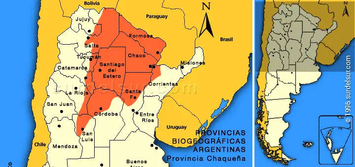
The Chaco Province that belongs to the Chaco Domain is formed by the following Argentina Provinces: Formosa, Chaco, east of Salta, Jujuy, Tucumán and Catamarca, west of Corrientes, north of Córdoba and Santa Fe, also reaching up into La Rioja and San Luis.
Climate
Warm and dry, with almost exclusively summer rainfalls, which are infrequent in the western region and abundant in the eastern region.
Landscape
This is largely a landscape of plains, with some depressions. In the west there appear low sierras.
The soils are sedimentary.
Vegetation
The vegetation varies between formations of big trees (commonly caducous xerophytes) and species from the grass family, palms, savannas, cardón covered areas and halophilous steppes.
Communities
Four districts have been identified, with various outstanding communities.
East Chaco District: East of Formosa and Chaco, west of Corrientes and north of Santa Fe. This is the most humid of all, and shows forests of white and red quebracho, algarroba and churqui, palms and high grass.
East Chaco District: West of Formosa and Chaco, north-west of Santa Fe, east of Salta, Jujuy, Tucumán and Catamarca and almost the whole of Santiago del Estero. It shows forests of white and red quebracho, palo santo, tusca, timbó, cardón covered areas, steppes and underbrush.
Chaco Sierra District: North-southwards, down the sides of the first sierras of Jujuy, Salta, Tucumán and Catamarca, spreading up to La Rioja, Córdoba and San Luis. It shows forests of horco quebracho, tabaquillo and grasslands.
Savanna District: In the north of Santa Fe. It is chiefly compounded by large gramineous species.
Fauna
Abundant and diversified. It includes numerous birds species (over 200), numerous large reptiles and around 50 amphibian species. The large rivers bounding the province in the north and the east show a very rich ichtyofauna.
Mammals: Golden weasel, red weasel, dwarf murine opposum, numerous bats, aguará guazú, foxes, coatí, ferrets, monkeys (howling, miriquiná and caí), otter rat, tuco-tuco, vizcacha, marshland deer, Pampa deer, brown corzuela, Chaco pichiciego, tatú carreta, tatú poyu, mataco, little ant eater, ant bear, labiate peccary, collar peccary, chancho quimilero, yaguarundí, wild cat, gato del pajonal, puma, big ferret, wood rabbit, etc.
Birds: Chuñas, inambú montaraz, Chaco martineta, ñandú, charata, pava del monte, jabirú, herons, baker bird, parakeets and parrots, etc. (over 200 bird species).
Reptiles: Terrestrial and aquatic turtles, lampalagua, rainbow boa, rattlesnake, yarará, tegu, red iguana, golden iguana, etc.
Amphibians: Rococo, escuerzo, coral frogs, different types of frogs and toads.
Fish: Pulmonate fish, rays, mojarras, dorado, boga, shad, surubí, patí, tararira, etc.
Human Activities
This is one of the most developed regions, with agriculture, livestock raising and wood development.
Woodland Province
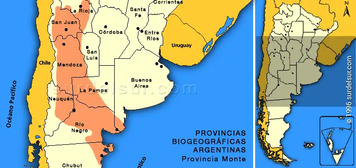
The Woodland Province that belongs to the Chaco Domain, draws a large curve starting from the Yocavil valley in Salta and Tucumán, spreading down Catamarca, La Rioja, San Juan, Mendoza, Neuquén, La Pampa, Río Negro and Chubut.
Climate
Generally dry, with rainfalls not exceeding the 200 mm (7.87 inches).
In the north it is warm and with summer rainfalls, whereas in the southern part it is cool, with winter and spring rainfalls.
Landscape
This is a landscape of plains, bolsons, mountain sides and plateaus. The soils are generally arenous and there are also saline and rocky areas.
Vegetation
The prevailing vegetation is xerophilous shrubby steppe, as wells as annual, succulent and prennial plants.
Communities
Various climax communities have been identified:
Jarillal: This association of several species of jarilla, combined in different ways, constituting the most characteristic vegetation of the region.
Thorny steppe: Compounded by thorny bushes, grass and cactuses.
Fauna
Many crepuscular or nocturnal species, with morphological and physiological features related to life in arid environments.
Mammals: Golden weasel, murine opposum, several types of bats, foxes, skunks, wildcat, yaguarondí, puma, Patagonian small ferret, mará, vizcacha, cuises, pichiciego, mataco, peludos, piche llorón, guanaco, etc.
Birds: Partridge, martinetas, loro barranquero, cata serrana, gallito copetón, gallito de arena, monterita, hawk, small grey hawk, carancho, purple eagle, jote, loro barranquero, etc.
Reptiles: Lampalagua, coral, yarará, culebras, lizards, iguanas, ututos, terrestrial turtles, etc.
Amphibians: Frogs, four eyed frog, toads.
Fish: Yuscas, small catfish, viejas de agua, Criollo trout, etc.
Human Activities
Pastoral subsistence. Important vine and vegetable crops, and fruit crops in the south area.
Espinal Province
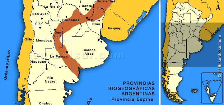
The Espinal Province that belongs to the Chaco Domain draws an arch ranging from the center of Corrientes and north of Entre Ríos, down Santa Fe, Córdoba, San Luis, La Pampa and Buenos Aires.
It is situated between Chaco and Woodland provinces.
Climate
It varies from warm and humid to mild and dry, the greatest quantity of rainfalls taking place in summer.
Landscape
This is a landscape of plains, with some low sierras scattered all around.
The soils are arenous or loesial.
Vegetation
The vegetation varies from large trees (xerophyle caducous forests), shrubby steppe, palms and species from the grass family.
Communities
Three districts have been identified, with different climax communities.
Ñandubay District: It encompasses the portion of the province corresponding to Corrientes, Entre Ríos and Santa Fe. It shows several ñandubay and algarroba forests. There are also palms, gramineous steppe and grasslands.
Algarroba District: In the center of Santa Fe and Córdoba, up to the north of San Luis. The algarroba and hackberry tree forests are typical of this region and in some areas there are gramineous prairies.
Calden District: From the center of San Luis, down La Pampa up to the south of Buenos Aires. The typical vegetation t’pica used to be the calden forest, currently reduced to critical levels. There are also gramineous steppe and underbrush.
Fauna
Similar to that of the Chaco Province .
Human Activities
Agriculture and livestock raising are well developed and an intense wood development took place in this area.
Pampa Province
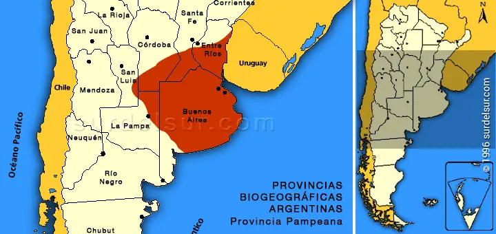
The Pampa Province that belongs to the Chaco Domain is formed by the following Argentina Provinces: Buenos Aires, south of Entre Ríos, Santa Fe and Cordoba, east of La Pampa and a small part of San Luis.
It is situated between the Espinal Province and the Atlantic Ocean.
Climate
Mild-warm; it rains all year round and there is a north-south gradient with reference to rainfalls.
Landscape
This is a landscape of plains with some low sierras.
The soils are varied, from black and very fertile to rocky or arenous.
Vegetation
The grass family (steppe type) prevails.
Communities
Four districts have been identified, with several climax communities. A constant in the different districts of this province is the deep alteration suffered by the original vegetation on account of anthropogenic activities.
Uruguay District: It covers the north of Buenos Aires, south of Santa Fe and south-east of Entre Ríos. The grass family prevails.
East Pampa District: North-east of Buenos Aires, up to the Olavarría sierras. The vegetation frequently includes gramineous species, rushes and cattails, etc.
West Pampa District: It spreads from the norht-east of Buenos Aires, the norht-east of La Pampa and the south of Córdoba. The grass family prevails.
Southern Pampa District: In the province of Buenos Aires, from the sierras establishing the limit with the East Pampa District southwards, near Bahía Blanca. The taller gramineous plant prevail, leaving bare patches of land in between.
Fauna
Two regions are differenciated, the first near the coast of the Paraná-Plata system, which shows similarities with the animals of the Paraná Province, and the other being the Pampa proper, with some characteristics common to the fauna of the Chaco-Woodland- Espinal system.
Mammals: Golden weasel, red weasel, small weasel, murine opposum, vizcacha, Pampa skunk, fox, ferret, wildcat, lobito de río, marshland deer, Pampas deer, peludo, armadillo, carpincho, tuco-tuco, various types of mice and rats, etc.
Birds: Cotorra, woodpeckers, baker bird, cabecita negra, calander, thrush, naranjeros, baker birds, partridge, martinetas, atajacaminos, federal, monjita, chingolo, black head duck, picazo duck, polla de agua, chajá, cañada crow, chimango, carancho, caracolero, bell tower owl, country owl, lead-colored hawk, teros, ñandú, etc.
Reptiles: Ampalagua, rainbow boa, various types of culebras, yarará, rattlesnake and coral, various lizards, aquatic turtles, etc.
Amphibians: Frogs, toads, escuerzos and arboreal frogs.
Fish: Lamprey, Criollo eel, silversmelt, various types of mojarras, madrecita, chanchita, tararira, palometa, shad, boga, viejas de agua, etc.
Human Activities
Agricultural and livestock raising activities on a large scale. It is the most densely populated region of the country.