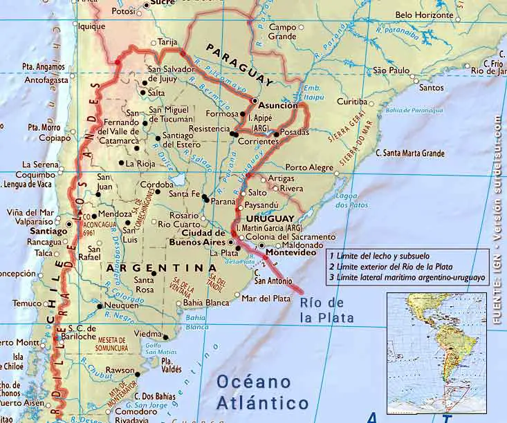
The Río de la Plata, the widest in the world, is located in South America on the border between Argentina and Uruguay. It arises from the confluence of the Paraná and Uruguay rivers, extending from northwest to southeast, to later flow into the South Atlantic. The Río de la Plata belongs to the Cuenca del Plata, which is the fifth largest in the world and second in South America.
CONTENT
Río de la Plata Geographical Location
The Río de la Plata is located in South America between the coordinates 34°52′59″S 56°42′49″W.
It is the border between Argentina and Uruguay
Four of the main cities of Argentina and Montevideo are on the banks of the Río de la Plata: The Autonomous City of Buenos Aires and La Plata (Argentina); Montevideo and Colonia del Sacramento (Uruguay).
How Big is the Widest River in the World
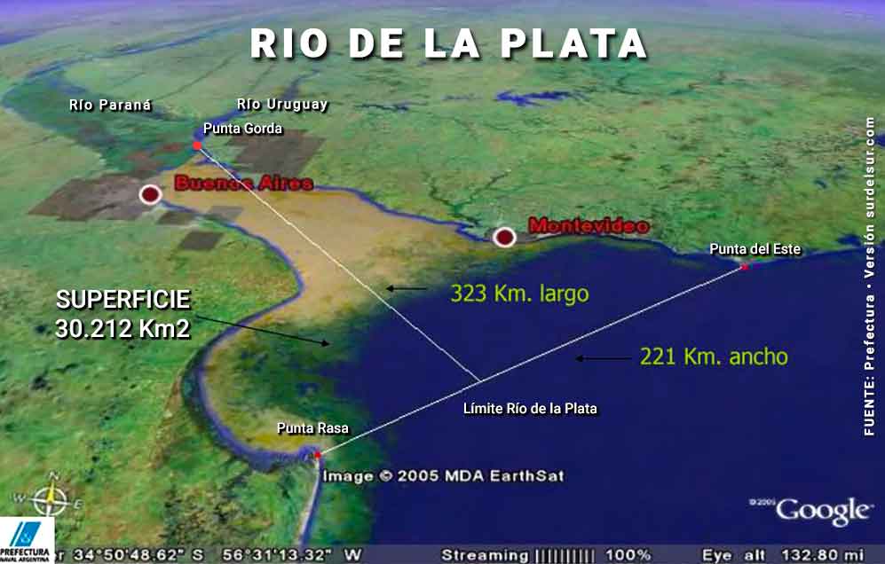
- Width: 221 km (137 mi) is measured on the imaginary line that joins Punta del Este (Uruguay) with Punta Rasa (Argentina).
- Length: 323 km is measured from Punta Gorda perpendicular to the base of the triangle, which is the widest part.
- Surface: Triangular area of 30,212 km2
- Average depth: 10 m. It varies between 0.60 m near the confluence between the Paraná and the Uruguay River up to a maximum of 25 m above the imaginary line that determines its outer limit.
- Average flow: 23,000 m3/sec
Rio de la Plata Inphographic Map
Where does the Río de la Plata Begin and End?
LAW No. 20,645 “Treaty of the Río de la Plata and its Maritime Front” describes the limits as follows:
The Río de la Plata extends from the parallel of Punta Gorda to the imaginary straight line that joins Punta del Este (Oriental Republic of Uruguay) with Punta Rasa del Cabo San Antonio (Argentine Republic), in accordance with the provisions of the Treaty of Limits of the Uruguay River of April 7, 1961 and in the Joint Declaration on the Outer Limit of the Río de la Plata of January 30, 1961
Source: LAW No. 20,645 “Treaty of the Río de la Plata and its Maritime Front” 1973
What is the Río de la Plata like?
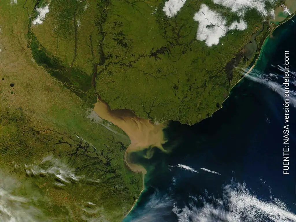
With a width of 221 km, the Río de la Plata looks more like a sea than a river, which is why it was baptized by its discoverer Juan Díaz de Solís as Mar Dulce. Among specialists there is no consensus on whether it is a river or an estuary, however as a general rule in Uruguay and Argentina it is considered a river.
Color of the Waters
Among the river’s most notable features is its leonine brown color. This is due to the enormous amount of sediment that it carries, between 80 and 160 million tons per year, mainly from the Paraná River. These suspended sediments are made up of a mixture of sand, silt, and clay, generating cloudier waters on the Argentinian coast. This is also due to the difference in color on the Uruguayan riverside with clearer waters and white sand beaches since it receives the contribution of the Uruguay River.
Winding through the center, the Río Paraná runs north to south. A tributary of the Río de la Plata, its waters appear brown due to sediment. It eventually drains into the Delta del Paraná and the Río de la Plata Estuary.
At the Atlantic, where the Río de la Plata empties, the brown, sediment-filled river water mixes with clearer ocean water. This creates swirls and cloudy formations.
Climatic Factors
The river presents a very large climatic variability associated with the variability of the atmosphere on a planetary scale, especially associated with the El Niño and La Niña cycles.
The Sudestada is a climatic phenomenon that affects the Río de la Plata and is characterized by persistent, regular to strong winds from the southeast, relatively low temperatures and generally accompanied by rains of varying intensity. The Pampero is a wind that blows from the southwest, precisely from the South Pacific Anticyclone to the Río de la Plata Cyclone, characterized by a mass of cold and dry air.
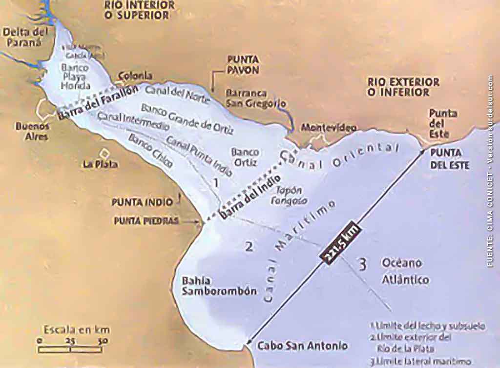
Rio de la Plata Geographical Zones Map
Geographical Zones Characteristics
- The internal or upper region, from the parallel of Punta Gorda to the imaginary line that joins the Colonia lighthouse with Punta Lara, has a substratum of fine sand, silt, and clay.
- The intermediate region, between Colonia and Punta Lara to Punta Espinillo Montevideo with Punta Piedras, is where the transport of fine suspended sediments occurs.
- The external region extends to Punta del Este (Uruguay) and Samborombón Bay (Argentina), the deepest stretch and with an important marine influence. The saline intrusion into the river reaches the area between Punta Piedras and the mouth of the Santa Lucía River. A saline tongue of marine waters slides along the bottom. Meanwhile, a superficial current of fresh water, coming from the rains and from the Paraná and Uruguay rivers that drain into the Río de la Plata, slides along the surface in the opposite direction.
Estuary shores
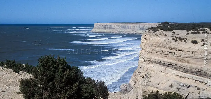
The Uruguayan coast belongs to the geological formation of the Brasilia massif. It is characterized by high coasts and sandy beaches, surrounded by dunes and separated by rocky capes.
The Argentine coast, on the other hand, corresponds to the Pampa sedimentary basin, characterized by low shores and silt plateaus that alternate with muddy plains. On this bank of the river, the Samborombón Bay stands out, whose coastline is about 180 km long, interrupted by numerous water courses, the most important being the Samborombón and Salado rivers.
Main tributaries of the Río de la Plata
The Río de la Plata is formed by the confluence of two great rivers, the Paraná and the Uruguay. The latter forms the natural limit with Uruguay and Brazil.
The main tributaries of the Uruguayan coast of the Río de la Plata are the San Juan, Rosario, and Santa Lucía rivers and the Solís Grande stream.
The main tributaries of the Argentine coast of the Río de la Plata are the Arroyo del Medio and Maldonado, the Luján, Reconquista, Matanza-Riachuelo, Santiago, Samborombón and Salado rivers, among many others. The Salado River stands out particularly for its greater extension
Plata Basin, the Second Greatest in South America
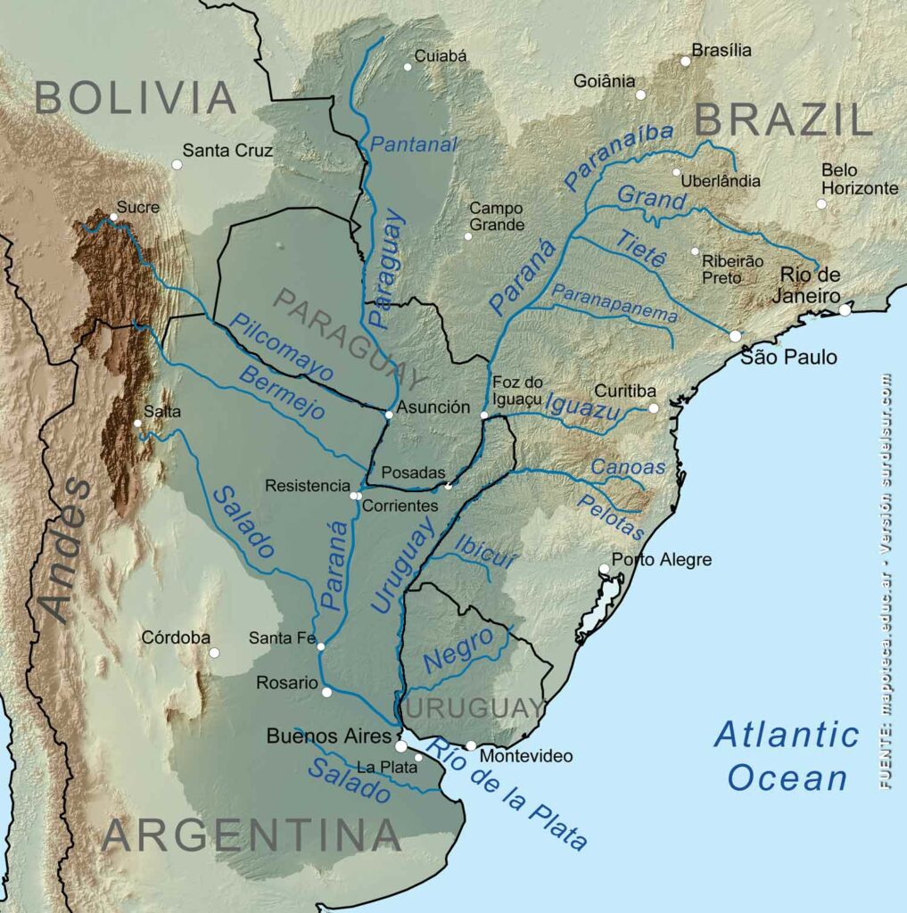
The Río de la Plata is part of the 3.1 million km2 Cuenca del Plata, the second most important river basin in South America and fifth globally.
The waters of two large rivers of the Argentine hydrographic system converge in the Río de la Plata: the Paraná and Uruguay, which, in turn, collect the flow of other very important rivers, such as Paraguay, the Bermejo, the Pilcomayo, and the Iguazú, among many other rivers and streams.
The fluvial complex of the La Plata Basin forms the main recharge system of the Guaraní aquifer, the third continental freshwater reserve in the world.
See more about the Plata Basin, a fundamental part of the hydrography of Argentina
History of the Río de la Plata Discovery
The Río de la Plata was the first discovery of the Spanish conquistadors in Argentine lands. Looking for a passage between both oceans, Juan Díaz de Solís on February 2, 1516, found a river that looked more like a sea than a river and he called it Mar Dulce.
The expedition members assumed that the Río de la Plata was the access door to the silver route. The magnificent vision of that immense river, the widest river in the world, stimulated for decades the imagination of the conquerors who came for the riches of the white king and the Sierra de la Plata.
Name’s Origin of the Great River
Solís, its discoverer, called it Mar Dulce (Swit See). The Spanish, in homage to its discoverer, killed by the Indians during the expedition, called it Río de Solis. The Portuguese, who disputed the territory with the Spanish, did not want to call it Río de Solís, because it implied the tacit acceptance of belonging to the Spanish. For this reason, they called it Río de la Plata, since they thought it would lead them to the Sierra de la Plata. Finally, it took root in the memory of the world as Río de la Plata.
WAS THE ARTICLE USEFUL TO YOU? SAVE IT!!
READ THE RELATED ARTICLE…!
YOU MAY ALSO LIKE…

